 Facebook
 Twitter
 LINE
LINE
1. Thermal Environment Analysis
(1) Temperature Distribution and Characteristic Analysis
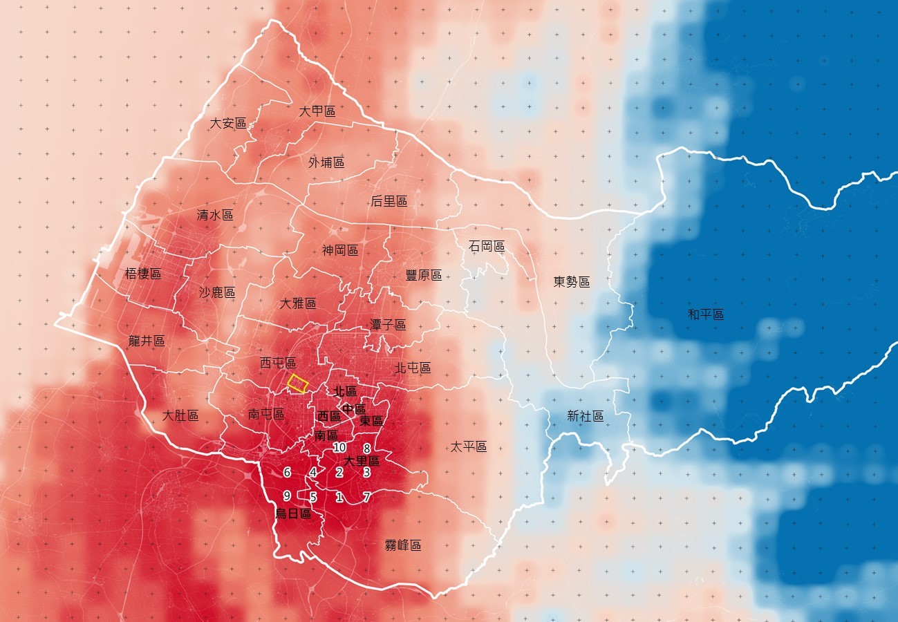
We analyzed long-term temperature data in Taichung City from 2011 to 2018 and found that, according to the reconstruction data of Taiwan's historical climate from TCCIP, the high-temperature centers of the urban heat island effect are mainly concentrated in the Nantun, Wufeng, Dali, and Wuri areas in the basin (Figure 1).
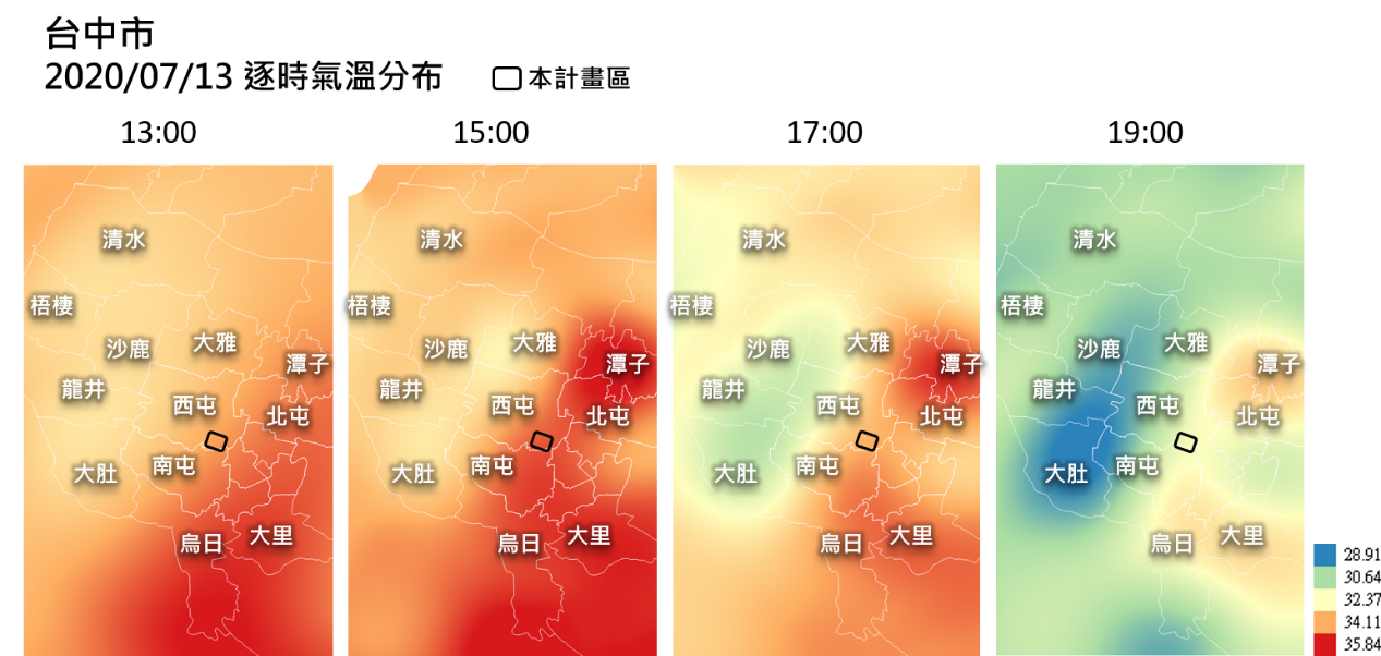
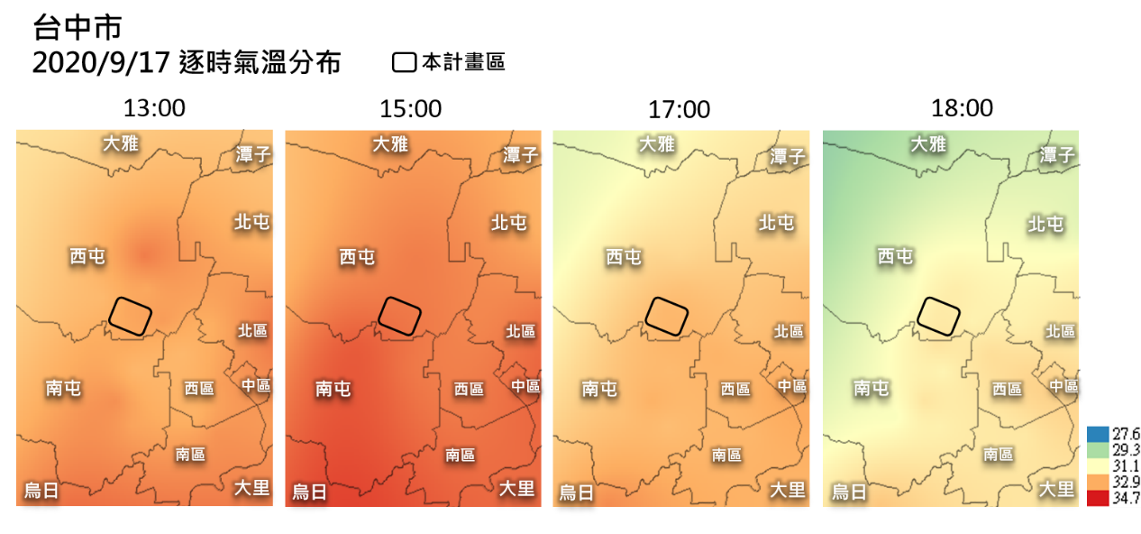
The planned area is not part of the high-temperature center. However, there is a phenomenon of heat storage in the planned area based on the hourly temperature distribution maps on July 13 and September 17, 2020 (Figures 2 and 3). The temperature remains relatively high until the evening and is higher than the western side of the planned area.
(2) Distribution and Characteristic Analysis of Wind Corridors
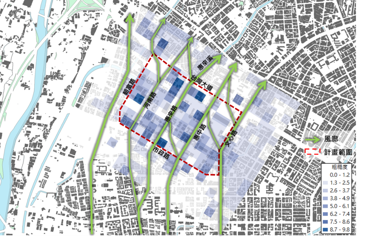
By utilizing the DSM (digital surface model) or the high-rise data of buildings, we calculate the roughness of the ground surface. We also adopt the minimum path method to calculate the ventilation potential of the constant wind direction. Then visualize the main wind corridors in the city, and draw the ventilation corridor path map. The constant wind direction in Taichung City is south in summer and north in winter. Besides, the frequency of west winds blowing from May to July mornings also reaches 50%. The urban heat island effect has a significant impact in summer. By enhancing the ventilation efficiency of the city, we can potentially mitigate the heat island effect and yield positive outcomes.
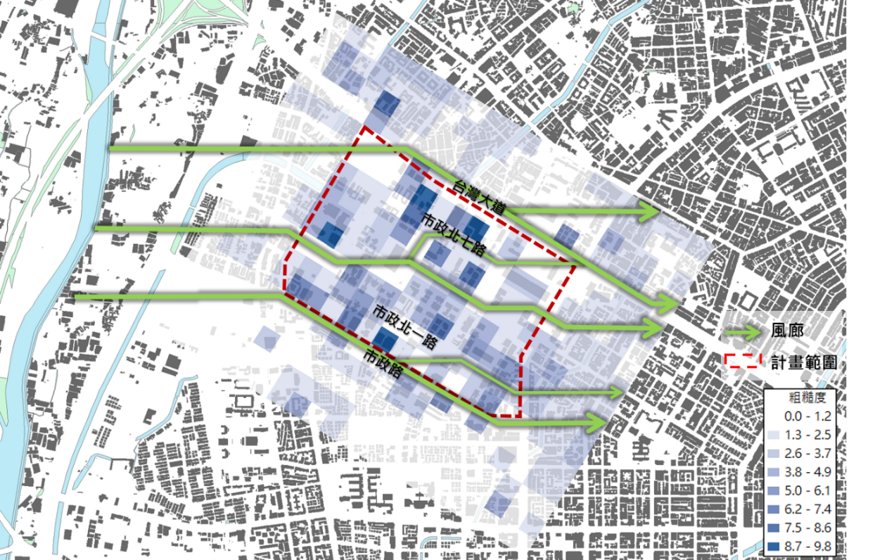
Therefore, the primary setting of the wind corridor map of this project is to draw the wind corridor path map based on the south wind direction of the summer continuing wind in Taichung City and the west wind direction as the secondary one. The deeper the grid in the wind corridor diagram, the higher the roughness, meaning the wind speed is low, and the wind is not easy to pass through. As shown in Figure 4, the primary wind corridors distribute along the west side of Chaofu Road, Henan Road, Maple Garden, Huilai Road, Huilai Creek, Huizhong Road, and Wenxin Road from south to north. The secondary wind corridors (Figure 5) roughly distribute along Taiwan Boulevard, Shizheng North 7 Road, Summer Green, New Civic Center Park, and Shizheng Road from west to east.
(3) Airflow Distribution
We conducted a computational fluid dynamics (CFD) simulation using the software FlowDesigner to model the current airflow distribution in the project area. The simulated wind direction is the constant south wind direction in the planned area, with an average wind speed of 2.85 m/s at a height of 2 m during the summer day.
We show the simulation results at a height of 1.5 m in Figure 6. In densely populated areas, the internal wind speed is relatively low to affect the surrounding downwind area, roughly consistent with the previous wind corridor analysis. The wind speed is powerful on several primary roads and open spaces in the park square, forming a wind hole.
2. Heat Island Adaptation Strategy
(1) Short Term: Landscape greening and building energy saving and cooling
We aim at urban hotspots and improve the urban environment using landscape engineering in the short term. Prioritize public land and public buildings promotion as demonstration areas to create cold zones in urban. Moreover, the primary cause of urban high temperatures still includes building heat dissipation. To address this issue, we advocate for the installation of livable building facilities such as vertical greening, multi-story terraces, and sunshade walls. These measures aim to reduce the heat dissipation from buildings and gradually mitigate the heat island effect.
(2) Medium term: Sun-shade environment improvement
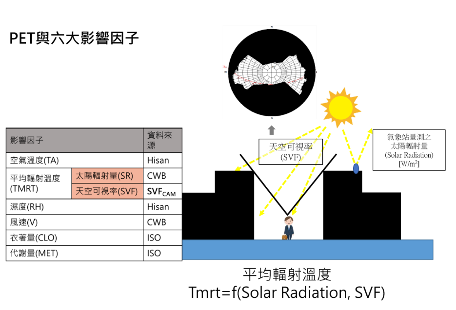
One of the significant concerns under the urban heat island effect is mitigating the heat sensation experienced by pedestrians outdoors. There are six primary factors that influence thermal comfort: air temperature, average radiation temperature, humidity, wind speed, clothing amount, and metabolic capacity (Figure 7). The average radiation temperature includes solar radiation and sky visibility. The sky visibility represents the degree to which the sky obscures. The smaller the sky visibility, the higher the degree of shading, and the human body receives the smaller the amount of solar radiation, making it more comfortable to feel. Therefore, adding good shade in urban outdoor environments can reduce the average radiation temperature and increase thermal comfort effectively.
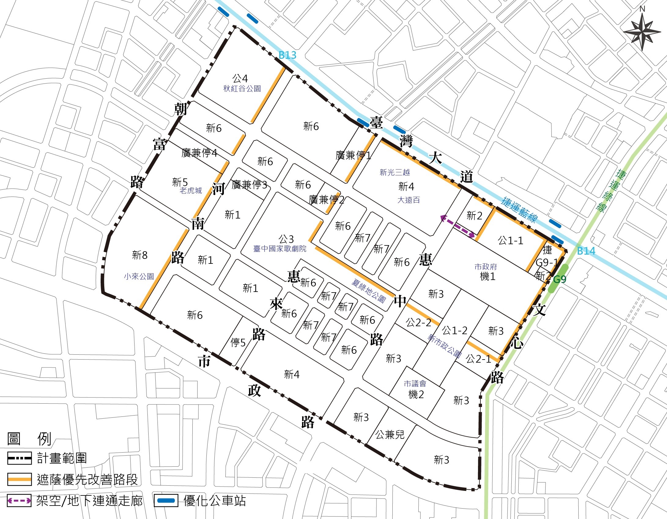
We suggest integrating the public transportation system with the aim of providing sufficient shade along the main pedestrian routes to enhance the comfort of pedestrians. For the main pedestrian flow sections, such as the administrative office, shopping consumption, arts and leisure, and commercial activities in the planned area, we shall prioritize the walking environment improvement using natural shading (tree corridors) (see Figure 8).
(3) Long Term: Potential wind corridors for ventilation and cooling
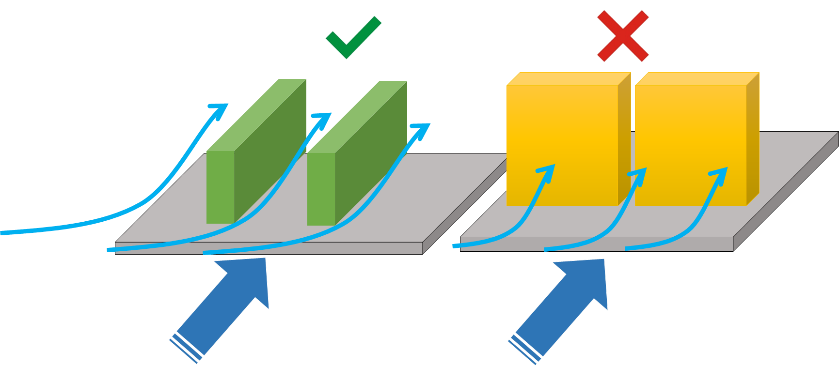
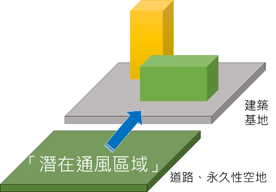
During base development, we need to ensure ventilation and comfort within one's base and that others have opportunities for ventilation. That gives different bases the right to receive the wind and the obligation to transmit it to the next foundation. In the same foundation with the same floor area, if only we configure the building form for all the constant wind-flow passing, we can improve the urban wind environment (Figure 9).
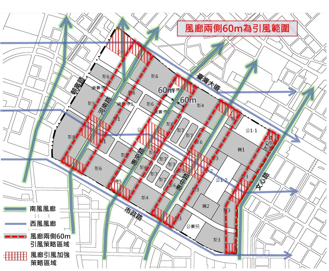
Maintaining adequate ventilation in the urban environment is crucial to dissipate accumulated heat and reduce the urban heat island effect. And introducing the wind from the wind gallery to the surrounding base can increase the overall ventilation effect. Therefore, we recommend setting the 60-meter range on both sides of the boundary line of the road that the wind corridor passes as the "wind-inducing strategy area" (Figure 11). Guarantee the ventilation quality of the foundation by maintaining a certain building distance and improving the ventilation potential of the building base. So we can introduce the wind energy on the primary wind hole into the foundation and avoid insufficient ventilation on the leeward of the site. The range of induced wind is 60 meters based on relevant foreign literature. The 60 meters on both sides and the road width of about 150 meters can achieve better street ventilation conditions. And two wind corridors pass through the junction of the primary and the secondary wind corridor. Therefore, we recommend setting it as a "wind-inducing enhancing strategy area" to prevent the building from blocking the progress of the primary winding. For the evaluation method of wind induction in the mentioned areas, refer to the site ventilation rate (SVR) method used in the "Regulations of Bulk Reward for Urban Renewal in Taichung City" and to confine the distance between adjacent buildings.
:::
Current Location
Home
> Main Tree
> Service
> Development Planning & Projects
share
The New Civic Center Exclusive Area
Related pictures

- Data update: 2023-07-04
- Publish Date: 2023-06-29
- Source:
- Hit Count: 2278